Could this new scanning technology transform soil remediation?
10 December 2024
A new multispectral LiDAR device capable of detecting hydrocarbon traces in soil has been unveiled by IRIDESENSE, a French start-up technology firm specialising in advanced 3D scanning systems.
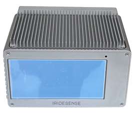
 The Multispectural LiDAR scanning device is currently in development. (PHOTO: Iridesense)
The device, which is still in the development stage, represents a potential shift in soil remediation by enabling remote, real-time identification of contaminated areas.
Developed in collaboration with Colas Environnement—a subsidiary of Bouygues—the sensor uses lasers and artificial intelligence to detect hydrocarbon pollution from distances of up to 100 metres. The results are then rendered as a detailed 3D map, with contaminated zones clearly marked.
Current soil decontamination practices involve taking physical samples across large areas and conducting laboratory analysis, a process that can take several days and disrupt project timelines. IRIDESENSE’s technology aims to streamline this by providing immediate on-site results, potentially reducing both costs and delays while increasing the accuracy of site assessments.
During recent pilot testing, the LiDAR’s findings were cross-referenced with laboratory analyses of soil samples. The technology was able to detect contamination levels above 500 mg/kg of dry mass, marking these areas on its generated maps.
While the sensor remains in the development phase, with further testing needed to validate its performance in varying conditions and environments, IRIDESENSE says the multispectral LiDAR will be able to provide a range of capabilities.
The current design of the LiDAR device enables it to operate under any weather or lighting conditions without requiring recalibration, ensuring reliability in diverse environments. Additionally, the high-resolution maps it produces have a precision of up to 10 sq cm, marking contaminated areas clearly for immediate action.
 The devices produces a map image that identifies areas of hydrocarbon pollutants. (IMAGE: Iridesense)
Compact and portable, users will be able to easily deploy the sensor, which has a plug-and-play setup, making it a practical tool for on-site assessments.
IRIDESENSE says that, once at a commercially viable stage, these features will make the technology a potential game-changer in soil remediation, offering faster, more accurate evaluations of contamination compared to traditional sampling and laboratory testing methods.
Arnault Perrault, Director of Colas Environnement, commented on the pilot collaboration: “Although still in the evaluation phase, we see potential in this technology to enhance the efficacy and sustainability of our soil remediation projects.”
IRIDESENSE co-founder Nadine Buard added: “We are working to refine the multispectral LiDAR to better meet industry needs and advance the rehabilitation of contaminated sites.”
While further developments and evaluations will determine its viability for widespread application, if successfully implemented, the technology could support broader environmental goals, such as the French government’s Zéro Artificialisation Nette policy to reduce soil pollution.
CONNECT WITH THE TEAM


